Devil’s Tower
 We left the Little Bighorn battle site, and, following the
route we originally planned, drove all the way back past Sheridan to the
outskirts of Buffalo, WY, where we ate lunch at Pistol Pete’s Café. A deer
crossed the road in front of us as we were making our way back to I-90. All our
driving in Montana had been on the Crow reservation, where — except for
occasional glimpses of the Little Big Horn River valley — the scenery was
rolling grasslands that looked a bit greener than most of Wyoming. The battlefield
was quite typical in this respect. Wyoming, however, especially now as we
headed east from Buffalo, looked a good deal dryer until we began to approach
the Black Hills. From time to time we again spotted small groups of antelope
grazing near the road.
From Moorcroft, where we stopped to buy gas, we turned off the interstate toward Devil’s Tower, driving now through richer, rolling green country with many ranches visible among the hills.
We reached the Devil’s Tower National Monument not long after four. Although there were some clouds in the sky, the afternoon light was golden and beautiful on the Tower and the nearby red cliffs.
 According to the park brochure, the Devil’s Tower was formed
by molten magma welling up into the layers of sedimentary rock above it 60
million years ago. When it cooled, still underground, the magma crystallized
into the columns that compose the Tower and make it unique among Western rock
formations. During the millions of years that followed, the surrounding rock
eroded away and left the tower standing — like the buttes and pinnacles of
Monument Valley, but completely different in structure and appearance.
It was named “Devil’s Tower” in 1875 by Col. Richard Dodge, the commander of the U.S. Army expedition that found gold in the Black Hills (and more or less indirectly started the war that killed Custer and his men). Challenged to explain the name, Dodge claimed that some Indians had told him it was called ‘bad god’s house’ in their language, but no one has ever been able to verify this, and the English name is thought to have been the colonel’s own bright idea.
 Indians have several different names for Devil’s Tower;
“Bear Lodge” (Kiowa) is typical. Legends associate the place with mythological
bears. It is still sacred to many tribal groups, and people come to tie prayer
ribbons and similar symbolic offerings to the trees around the tower’s base.
Signs instruct visitors not to disturb these.
 The old sedimentary rock that surrounds the base of the tower
is bright red, in contrast to the gray of the tower itself. The low cliffs along the Belle Fourchette River glowed
beautifully with the declining sun on them.
 Another sight below the Tower is a
huge prairie dog town that occupies several acres. Those citizens who live near
the road are not the least bit shy when a car pulls up — they’re too cautious
to beg, but it’s clear that they wouldn’t be the least bit disturbed by a
handout. We scrupulously avoided feeding them, which is a bad idea from several
points of view, but I took advantage of their nonchalance to get a few
pictures.
The Wrong Sundance
It was after six when we got to the motel in Sundance, and as the weather was now threatening we went immediately to dine at the Aro Family Restaurant on decent if unspectacular food. I liked the chicken-fried steak with white gravy, even though it fell a good way short of Threadgill’s, and Dorothea enjoyed her 8-oz. sirloin steak although she couldn’t eat all of it. The vegetable of the day, on both our plates, was Del Monte canned green beans. The restaurant was not so dedicated to family values that it refused to serve alcohol, so I drank two bottles of Fat Tire Amber Ale.
We had hoped to find more interesting dining spots in a town that hosts an important film festival, and perhaps we would have. To our embarrassment, we learned that Mr. Redford holds his festival not here, but in Park City, Utah — the festival is named after himself, in character as the Sundance Kid. The young woman who broke this news to Dorothea expressed some annoyance at Redford for snubbing the real Sundance that had given its name to the outlaw he played in the movie. “Nothing at all happens here,” she grumbled.
We just missed being rained on both before and after dinner, and heavy rain began once we were back in the motel. We hoped that it might take some of the dust off the car, but either the wind was wrong or the car was too dirty to be cleaned by a mere thunderstorm.
When we got up the next morning, the motel had no hot water. Dorothea phoned the desk clerk, who told her that the pilot lights were out on both water heaters, and the problem was being worked on. Dorothea had showered the previous night, as per her custom on the trip, but I had to manage what I could in the way of a cold, soapless sponge bath.
While we were eating breakfast, a propane delivery man arrived. The desk called to inform us that “our propane problem has been taken care of,” and that hot water was now available. They said we didn’t have to check out until noon, but we chose to go forth as we were.
The Black Hills
 This day we did depart slightly from our planned route.
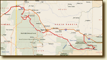
As per schedule, we turned at Spearfish and took South Dakota Rte 14 (Alt) down Spearfish Canyon into the Black Hills. After that, however, we changed our minds about returning to I-90 and instead turned south on US-385, then east on state route
44, heading for the eastern end of the Badlands loop road. This added a good
deal of time to the trip, but it didn’t prevent us from doing everything we wanted
to do.
 As our first experience of the Black Hills proper, Spearfish
Canyon was a very beautiful drive, although the direction of the morning sunlight frustrated most of our
efforts to document this with our cameras.
Once past the canyon, we drove on through Deadwood and up its restored main street. As restored, the town recalls a later period than the 1870s or 1880s, when Wyatt Earp, Doc Holliday, and Calamity Jane hung out there, and the town’s most celebrated historic event — the shooting of Wild Bill Hickock — took place. In spite of Hickock’s name being put on just about everything, Deadwood looks much the way it must have looked between 1900 and 1920, when the nearby gold mines were still flourishing.
Going south on US-385, we passed through pine-covered hills — there were no spectacular vistas, but it was cool and pleasant. We speculated that the dark color of the evergreens gave the Black Hills their name. They provide a welcome contrast to the dry grasslands that surround them. Rte 44, when we turned east, took us into Rapid City, where we searched diligently for a place to eat lunch and wound up at the Firehouse Brewery. I passed on beer, since I wasn't planning to doze the afternoon away, but I had some of the good birch beer that they also brew. The food was excellent. I had a cup of beer-and-cheese soup, made with Gorgonzola, and a half Reuben sandwich. They served the Russian dressing on the side, and I ignored it, an act of abstention that I feel improves this sandwich considerably. Dorothea had a half Caesar salad with chicken, which the waitress kindly (and truthfully) advised her would be plenty big enough.
This section last updated 2-5-2005
