For a long time the Sava marked the border between independent Serbia and the Austro-Hungarian Empire, leading some 19th-century statesman to remark that Belgrade should be a frontier post rather than the national capital. This genuine defense problem was eventually solved by the outcome of World War I, when the new Yugoslav state received a large piece of what had previously been Hungarian territory, though many of its inhabitants were Serbs.
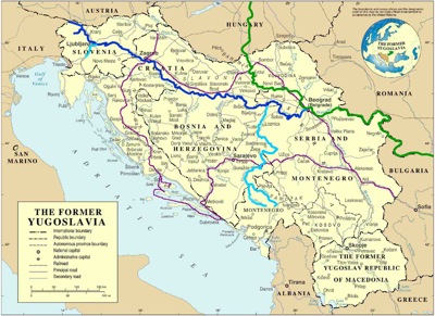
I've added thick lines and colors to this map to show the courses of the Sava (in dark blue) and the tributaries (in light blue) that I've mentioned above: the Ljubljanica in Slovenia, and the Drina in Bosnia-Herzegovina (along with the two Montenegrin rivers, the Tara and the Piva, that come together to create it). You can see on the map that many other rivers feed into the Sava as well. The Danube, into which all their water goes, is shown in green. There's something astonishing about the recognition that so much water will travel from places only a few miles from the Adriatic all the way to the Black Sea.